Projects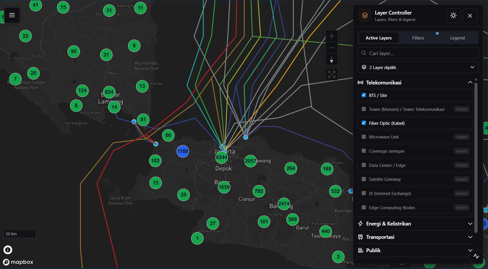
Buka tautan projectKembali ke daftar
ProjectGeospatial Visualization2024—
Geospatial Platform
High-performance geospatial visualization platform built on Mapbox, PostgreSQL Vector Tiles (MVT), and Golang — designed to explore and analyze large-scale infrastructure data through an interactive map interface across multiple domains including telecommunications, energy, transportation, and public facilities.
Tech Stack
- Go
- Gin
- PostgreSQL
- PostGIS
- Mapbox GL JS
Key Features
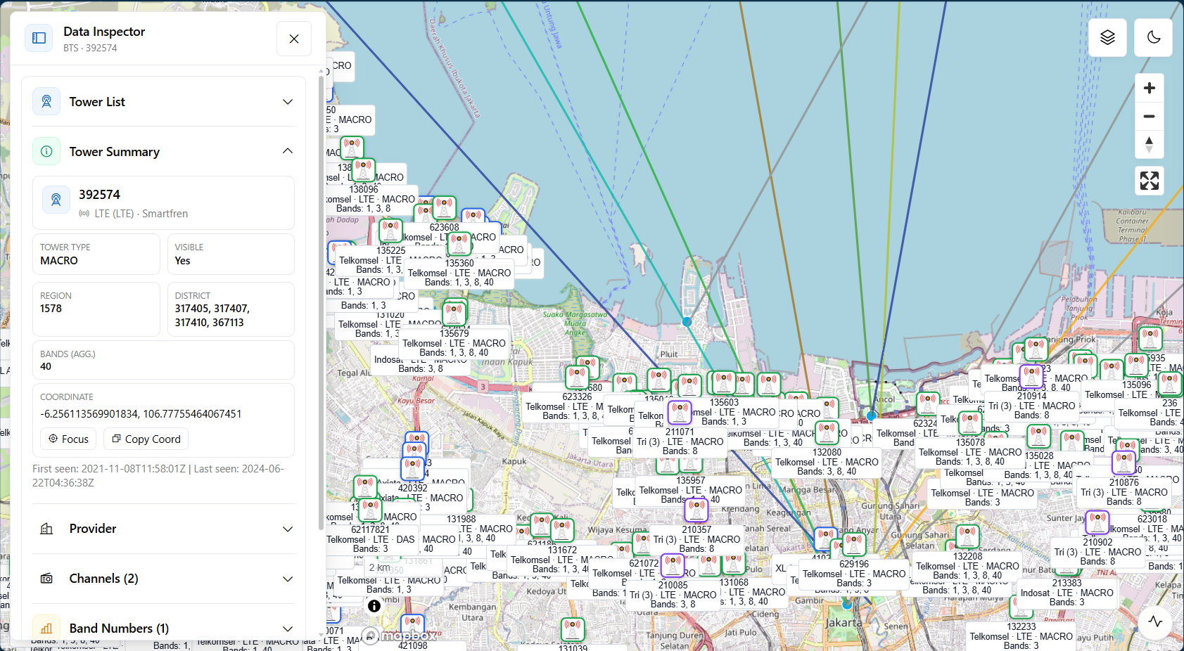
- Multi-layer infrastructure visualization: BTS/cell sites, fiber optic networks, data centers, transportation routes, and public facilities
- PostgreSQL/PostGIS-based Mapbox Vector Tile (MVT) generation for efficient large-dataset delivery
- Dynamic point clustering that aggregates nearby markers based on zoom level
- Advanced layer management — enable/disable layers, apply filters, inspect feature details
- High-performance spatial queries with server-side tile delivery and spatial indexing
Architecture
Tile-based geospatial pipeline
- 1.Spatial datasets stored and indexed in PostgreSQL with PostGIS extensions
- 2.MVT tiles generated at the database layer based on map zoom level
- 3.Golang (Gin) tile-serving APIs deliver vector tiles to the client
- 4.Mapbox GL JS renders tiles interactively in the browser with dynamic clustering
Data / Processing Flow
- 01Infrastructure datasets ingested and stored in PostgreSQL/PostGIS
- 02Tile generation converts spatial features to MVT based on zoom level
- 03Golang services expose tile endpoints with optimized query paths
- 04Mapbox GL JS renders tiles client-side enabling smooth zoom and pan
- 05Dynamic clustering aggregates high-density points at lower zoom levels
Highlights & Metrics
- Tile-based rendering for millions of geospatial features
- Dynamic point clustering reduces visual noise at all zoom levels
- Supports 5+ infrastructure domains in a single map view
Use Cases
- Infrastructure monitoring across multiple regions
- Telecommunications analysis — BTS sites, fiber optic, and coverage
- Network planning and coverage gap identification
- Spatial intelligence for decision-making
- Large-scale asset management and inventory
My Contributions
- Designed the vector tile architecture with PostgreSQL/PostGIS MVT generation.
- Developed tile-serving APIs using Golang and Gin.
- Implemented dynamic clustering for high-density point datasets.
- Integrated Mapbox GL JS with backend geospatial services.
- Supported multi-layer geospatial visualization and layer management.
- Optimized tile delivery and query performance for large datasets.
Technical Highlights
- PostgreSQL/PostGIS-based vector tile generation eliminates per-request GeoJSON serialization
- Dynamic clustering reduces visual noise and improves readability at all zoom levels
- Tile-based rendering scales to millions of geospatial features with low network overhead
- Multi-domain layer system supports 5+ infrastructure categories in a single map view
http://localhost:3000/projects/geospatial-platform